Ken-Betwa Link Project: A Landmark River Interlinking Initiative

Ken-Betwa Link Project
We will explore a very interesting and important topic: the Ken-Betwa Link Project, which is India’s first major river interlinking initiative. It's a fascinating blend of geography, history, and environmental science, so let’s dive in.
Understanding the Ken and Betwa Rivers
First, let’s talk about the two rivers involved in this project: Ken and Betwa. Both are tributaries of the Yamuna River.
-
Ken River:
- It originates near Ahirgawan village, in the Kaimur Hills of Jabalpur, Madhya Pradesh.
- It flows into the Yamuna at Chilla village, Uttar Pradesh.
- Did you know? Ken is famous for the Sajhar stone, a rare type of stone.
- Its major tributaries include Bawas, Dewar, Kaith, Baink, Kopra, and Bearma.
-
Betwa River:
- Betwa begins its journey from the Vindhya Range in Madhya Pradesh.
- It flows through Bundelkhand before meeting the Yamuna at Hamirpur, Uttar Pradesh.
- Fun fact: In ancient times, the Betwa River was known as Vetrawati.
- The important tributaries of Betwa are Newan, Orr, and Dhasan.
What is the Ken-Betwa Link Project?
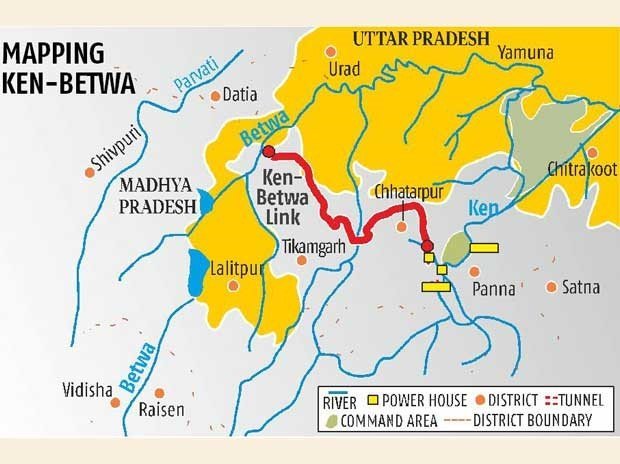
The Ken-Betwa Link Project, often called KBLP, is a large-scale plan to transfer surplus water from the Ken River to the Betwa River to solve water scarcity problems, especially in the Bundelkhand region. This area is known for droughts, so this project is expected to be a game-changer.
How Does It Work?
The project has two phases:
-
Phase I:
- Construction of the Daudhan Dam on the Ken River.
- Building tunnels and a Ken-Betwa Link Canal to transfer water.
-
Phase II:
- Building more infrastructure like the Lower Orr Dam, Bina Complex, and Kotha Barrage on Betwa tributaries.
.png) Benefits of the Project
Benefits of the Project
Now, you might wonder, "Why is this project so important?" Let me explain:
- Irrigation: It will provide water to 6.3 lakh hectares of farmland.
- Drinking Water: It will supply clean drinking water to 62 lakh people.
- Energy Generation: The project includes hydroelectric power stations that will produce 100 MW of electricity, along with 27 MW of solar power.
- Boost to Bundelkhand: This region will see significant agricultural and economic development.
Environmental Concerns
No big project comes without challenges. Let’s discuss the environmental issues related to this project:
- Panna Tiger Reserve:
- Over 10% of its core area could be submerged, affecting wildlife like tigers and vultures.
- Deforestation:
- Around 23 lakh trees might be cut down.
- Ecosystem Impact:
- Construction could disturb the local biodiversity.
The government has assured measures to minimize the environmental damage, but this remains a concern.
Historical Context of River-Linking in India
Did you know that the idea of linking rivers is not new? It goes back to the 19th century.
- Sir Arthur Cotton:
- He proposed connecting the Ganga and Cauvery for navigation and irrigation.
- Periyar Project (1895):
- Diverts water from Kerala’s Periyar River to Tamil Nadu’s Vaigai River.
- Dr. K.L. Rao’s National Water Grid:
- Proposed in the 1970s to solve water shortages.
- Garland Canal:
- Suggested by Captain Dinshaw J. Dastoor for redistributing water.
Finally, in 1980, the National Perspective Plan (NPP) was launched to officially interlink rivers.
National Perspective Plan (NPP)
The NPP, developed by the Ministry of Jal Shakti, has two main components:
- Himalayan Rivers Development:
- Focuses on transferring surplus water from eastern rivers like the Ganga and Brahmaputra to western regions.
- Peninsular Rivers Development:
- Links rivers in southern and central India, including the Ken-Betwa Link.
This plan includes 30 link projects (16 for peninsular rivers and 14 for Himalayan rivers).
Conclusion
So, the Ken-Betwa Link Project is a landmark initiative. It addresses critical water shortages, boosts agriculture, and supports economic growth. However, it also highlights the importance of balancing development with environmental conservation.
Remember, projects like this show how geography, engineering, and environmental science come together to solve real-world problems. I hope today’s class inspires you to think about sustainable solutions for our planet.
What's Your Reaction?


